|
<< Click to Display Table of Contents >> Hybrid Road Systems |
  
|
|
<< Click to Display Table of Contents >> Hybrid Road Systems |
  
|
The previous topics covered the set up and use of Roads on Terrain and Virtual Roads.
Roads on Terrain are roads where the full three-dimensional alignment of the road is specified.
Virtual Roads have start and end point specified as three-dimensional coordinates, user defined parameters are used by 3d-DigPlus to create an imaginary, virtual, three-dimensional road connecting the start and end points. During simulation trucks are simulated running along this Virtual Road.
Hybrid Roads involve a road system which consists of a mix of these road types. This involves creating at least the Main Haul Route and using Virtual Roads for the Excavation Access, Dump Access or both.
In a Simulation which models a large long term schedule, there are typically only a limited number of Main Haul Routes but a significant number of Excavation and Dump Access Roads. Often the Excavation and Dump accesses can be adequately modelled by Virtual Roads. The Main Haul Routes can usually be set up very quickly and if the Accesses are model by Virtual Roads these too can be rapidly set up. Hence the use of Virtual Roads can allow the rapid set up of complex simulations.
The procedure for setting up a Hybrid Road system is as follows:
1.Determine the location of the Main Haul Routes, and create a Road on Terrain for each of the Main Haul Routes required.
2.Open Terrain Window with a viewpoint which shows all excavation and dump locations and all Main Haul Routes.make sure the Window Appear in setting for Roads is set to show distance along Road. This will display the Main Haul Routes with markers and distances shown.
3.Identify the location of the access points for all Excavation and Dump accesses. The access points are the points where the access road intersects Main All Route. These access points are identified via the name of the Main Haul Route and the distance along the road at which the access point occurs. In a large simulation it may be necessary to prepare a table of take points for all accesses.
4.Determine suitable Virtual Road parameters for the Accesses.
5.On the Roads page of the Simulation Setting Dialog Assign roads to all Subsequence/Dumps and use the Virtual Road option as required.
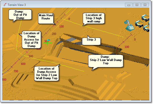
The figure below shows a Terrain View for a pit which will have a Hybrid Road system applied:

Terrain Window for Hybrid Road set up
In the pit shown above upper pass waste material for Strip 3 will be dumped in the dump indicated above as Strip 2 Low Wall Dump Top, the second dump in the Hierarchy is the one indicated as Out of Pit Dump.
Upper pass waste will be hauled to the Main Haul Route via Strip 3 high wall ramp. This ramp joins the Main Haul Route at distance 50 m.
The Strip 2 Low Wall Dump will be serviced via a ramp whose location is shown in the figure above. This ramp joins the Main Haul Route at distance 550 m.
The second Dump in the Hierarchy, Out of Pit Dump, is serviced via a ramp whose location is shown in the figure above. This ramp joins the Main Haul Route at distance 550 m.
Once the Main Haul Route has been created the above information is sufficient to assign the Hybrid Roads. The process of assigning roads, including Hybrid Roads, is explained in the topics under Assigning Roads and Accesses to Subsequences.