|
<< Click to Display Table of Contents >> Transferring Surfaces Between Files |
  
|
|
<< Click to Display Table of Contents >> Transferring Surfaces Between Files |
  
|
Frequently it will be required to transfer surfaces between 3d-DigPlus files. These could be terrain surfaces that of the product of excavation and dumping or Inner Surfaces which have been generated in one 3d-DigPlus file and are required for use in another.
3d-DigPlus has an internal surface file format called a bit file. Bit files save the 3d-DigPlus surface grids. These grids are saved complete with no loss of resolution.
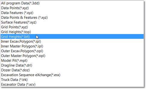
To use bit files use the standard menu option of File/Open and File/Save. In the Files of Type pulldown list for the dialog is produced by these commands you will see the option Surfrace Grid (*.bit):

Files of Type bit.
Note grids can also be saved with the similar option called top files. Top files are an ASCII file type and are much larger in size than the big files. Generally you should use bit files in preference.
When opening files there are two options; Terrain Grid and Surface Grid:

Opening bit Files.
Surface Grid will load the nominated bit file as a Inner Surface. This is the typical way to load bit files.
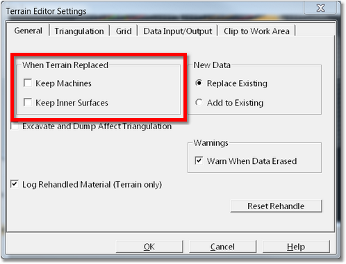
Terrain Grid will load the nominated file as a new Terrain Surface. The existing Terrain Surface will be replaced by the nominated file. This option should only be used under limited circumstances. By default loading the terrain surface in this manner will delete many elements including Inner Surfaces. Before using this option you should open the Terrain/Editor Settings dialog and on the General page select the options Keep Machines and Keep Inner Surfaces:

Keep Inner Surfaces Options.
Selecting these options will ensure that any Inner Surfaces, Layers and Machines will be kept when the new topography is imported.
Whenever possible it is recommended that the terrain is not replaced in this manner. If you wish to update the topography with say some recent survey data, if possible you should use the following procedure:
1.Load the updated topography as Inner Surface.
2.Set up a new Excavation Template with the options Excavate Only and Fill Only switched Off. On the Excavation Polygons page make the Bind Surface the newly imported Inner Surface. Make sure the General Log is a disused Material Log (this option will modify the nominated General Log).
3.Draw an Inner Polygon to encompass the area which has been modified and Excavate.
4.When complete delete the newly imported Inner Surface as it is no longer required.
The new data will be imposed on the existing Terrain Surface.