|
<< Click to Display Table of Contents >> Terrain Restore Points |
  
|
|
<< Click to Display Table of Contents >> Terrain Restore Points |
  
|
The Terrain Restore Point functionality allows the user to create Terrain Restore Points at various stages during a 3d-DigPlus simulation. Once a Restore Point is created it allows the Terrain Surface, Prime Surface and Material Logs to be restored to this state at any time.
3d-DigPlus is often used to test the feasibility of proposed mining methods. As a consequence it is often required to either refine a proposed method or to model several alternatives. This involves commencing with the starting topography, conducting one design option, and then returning to either the starting point or some intermediate point to conduct the modelling of another option. This process has traditionally been achieved by saving 3d-DigPlus design files at the start of the job and that key points throughout the modelling. Once the modelling of one option is complete the appropriate 3d-DigPlus file is reloaded an alternative option is modelled. This approach is still often the best method in many situations.
However it does have the disadvantage that if design elements are modified or created while working on a particular option, these modified or new elements will not be present in the previously saved files and hence not be available when modelling the alternative option. As an example, a dragline modelling exercise will generally start with a preliminary bench design. As the design of the first option progresses it frequently the case that this process will indicate that the bench elevation needs to be modified in some areas. If the bench design is modified part way through the modelling of one option, this updated design surface will not be available in the 3d-DigPlus files previously saved.
The use of restore points allows the current design file to have its Terrain Surface, Prime Surface and Material Logs restored to a previous state, but other design elements left intact. The use of Restore Points is critical for automated excavation and dump sequencing and truck and shovel simulation, however it does also have applicability for generic and dragline simulation.
Terrain Restore Points can be created at any time during the design process. Typically they are created at the start of the job prior to any simulation been conducted, and at any relevant Keypoints throughout the design.
Creating a Terrain Restore Point.
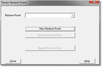
Restore Points are created by selecting Terrain/Restore Points from the Main Menu. This brings up the Terrain Restore Points dialog:

Terrain Restore Points Dialog.
To create a restore point the desired Terrain Restore Point click on the New Restore Point button. This will open the New Restore Point dialog:

New Terrain Restore Point Dialog.
To create the new Restore Point input a suitable name into the New Restore Point field and click okay.
Applying a Terrain Restore Point.
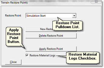
To apply at Terrain Restore Point select Terrain/Restore Points from the Main Menu. In the Terrain Restore Points dialog select the required Restore Point from the pulldown list and then click the Apply Restore Point button:

A message box will be produced warning that the terrain will be erased. On completion the Terrain Surface and the Prime Surface will be restored to the state that existed when the nominated Restore Point was created.
At the bottom of the Terrain Restore Point dialog is the Restore Material Logs checkbox. Simulations conducted after the creation of a Restore Point will add material to various Material Logs. This material is not relevant to the Restore Point State. When the Terrain is restored to the state of a particular Restore Point, it is appropriate that the Material Logs be restored to their Restore Point State to ensure consistency. The Material Log state is saved when a Restore Point is created. Checking the Restore Material Logs checkbox will ensure that the Material Logs are restored when the Restore Point is applied.
Frequently the Restore Point will be created prior to conducting any simulation. In such cases the Material Logs will contain no volume when the Restore Point is created, and when the Restore Point is applied to Material Logs will be returned to this empty state.

Warning
Restore Points should not be used as a substitute for saving 3d-DigPlus files. Even when restore points are used 3d-DigPlus files should still be saved on a regular basis. It is also recommended that an associated 3d-DigPlus file be saved when each Restore Point is created.
The following video clip demonstrates the use of restore points. In this video the file is at the state of commencement of an automated excavation and dump simulation. The simulation is run and the topography is restored: